
According to data from the U.S. Geological Survey (USGS), residents across the Los Angeles region were startled awake by a 3.8 magnitude earthquake in the early hours of Tuesday, July 2. The tremor struck at 2:29 a.m., its epicentre situated approximately 13 miles (ca. 21 km) southwest of Malibu, just off the coast.
Reports flooded in from numerous locations, spanning from Ventura to the San Diego County line, encompassing the San Fernando Valley, and reaching as far inland as Ontario. The widespread impact underscores the seismic reach of the event, leaving many residents shaken, but fortunately with no major damages reported.
The Uniform California Earthquake Rupture Forecast map hangs at a press conference in Los Angeles, California. Representatives of the Southern California Earthquake Center, the US Geological Survey, and the California Geologic Survey presented new statewide earthquake probabilities for California on April 14, 2008 in Los Angeles, California.
USGS Map of Recent Los Angeles Earthquake
As per the local report from KTLA 5, initially pegged at 4.1, the earthquake’s magnitude was later revised down to 3.8. The tremors rippled across Los Angeles County and reached into portions of Ventura, Orange, and Santa Barbara counties, as depicted on a USGS map.
Thankfully, there were no injuries or significant damage reported, with fire crews expressing relief regarding the state of infrastructure. Due to its relatively minor intensity, the quake did not trigger automatic cell phone alerts. USGS officials advised residents who experienced the shaking to adhere to protective measures such as “Drop, Cover, and Hold On.”
California experiences tens of thousands of earthquakes each year, but most are relatively minor in magnitude. Only a few hundred earthquakes surpass a magnitude of 3.0, and around 15 to 20 register at 4.0 or higher, as stated by the USGS. In the United States, California ranks second only to Alaska in terms of the frequency of recorded earthquakes annually.
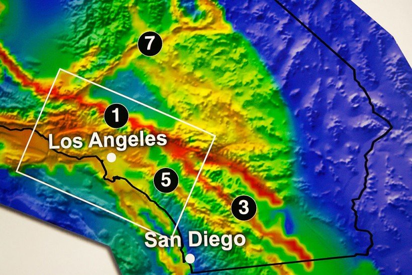
Risk of Los Angeles Getting Hit by an Earthquake
When considering earthquakes in Los Angeles, many people first think of the Southern San Andreas Fault. The California Earthquake Authority explains that this fault formed around 30 million years ago when the North American plate subducted a substantial section of the Fallon plate. Since its formation, the North American plate has been sliding past the Pacific plate along a strike-slip fault boundary.
Stretching along the northern side of the San Gabriel Mountains in Los Angeles County, the Southern San Andreas Fault stands as California’s longest fault line, capable of producing formidable earthquakes with magnitudes reaching as high as 8.
According to projections spanning a 30-year period starting from 2014, there exists a 75% likelihood of one or more earthquakes measuring 7.0 or greater striking Southern California.
Moreover, Los Angeles encounters earthquakes along lesser-known faults. In 2019, the Ridgecrest earthquakes shook the region, representing the most substantial seismic activity in California in more than twenty years. These quakes, measuring magnitudes of 6.4 and 7.1, hit southwest of Sear less Valley, delivering a force comparable to 45 nuclear bombs in the Mojave Desert.
In Los Angeles County, earthquakes are a regular occurrence, typically mild to moderate in intensity and causing limited damage. Nevertheless, every few years, seismologists anticipate a magnitude 6.0 or greater earthquake striking Southern California.
Experts like Lucy Jones caution that if such an earthquake were to occur along faults within metropolitan areas such as Hollywood, the consequences could be severe. These faults traverse densely populated regions, where thousands of buildings stand, posing a significant risk to millions of residents.
The potential fallout could include demolished free ways, fires sparked by ruptured gas lines, interruptions to the water supply, and prolonged outages of high-voltage power lines, resulting in days without electricity for Southern California residents. According to CoreLogic projections, a rupture along the Southern San Andreas Fault could jeopardize 3.5 million properties, with a collective rebuilding cost estimated at $289 billion.
Subscribe To Our Channel :- https://youtube.com/@s.anand1?si=9nXhmyrwVcleFLgc
About Us :-https://dailynewscountry.com